Hey GIS'ers !
Probably some of you might knew what i am about to show and explain. But for most of us, this might sound new and exciting. However, do not expect something flamboyant. Its just what i tried out of learning & curiosity.
Why Model & Automate ?
In the previous post, i have gone through the possible workflow of sorcing terrain data, processing it, visualizing & communicating it. But choosing a place (locality) inorder to get the terrain data, everytime for a set a localities might add work burdern due to repetitive actions. Similarly, striking out all the stuff that can be automated using existing free & open -- GIS tools & libraries, provides a great way of sharing the workflow itself with others who would like to do the same for their locality, instead of everytime following the generic workflow.
Fortunately GRASS GIS, QGIS offers versatile Modeling tools, that lets the programmers, designers, new comers to use the existing libraries, modules, scripts, etc... to build & test the required workflow. I will be using QGIS, as it serves as the best common place to utilize the GRASS GIS & other community libraries without any additional interfacing requirements. So now, with the requirment being set, functions to be automated need to be identified, and sequenced with the required data source, buffers, processing, visualization, data sink modules & routines.
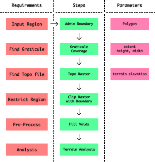
In QGIS, process modeler enables us to model & automate the work flow. The required functionality can be accessed from the list of available set of algorithms provided by the modeler. I have tried to use the available functionalities provided by the set of algorithms sourced by several packages available through process modeler, generalize the workflow, and abstract the whole work with optimal input and output parameters. Before doing it, my interpretation of workflow, and its model block diagram is shown below: